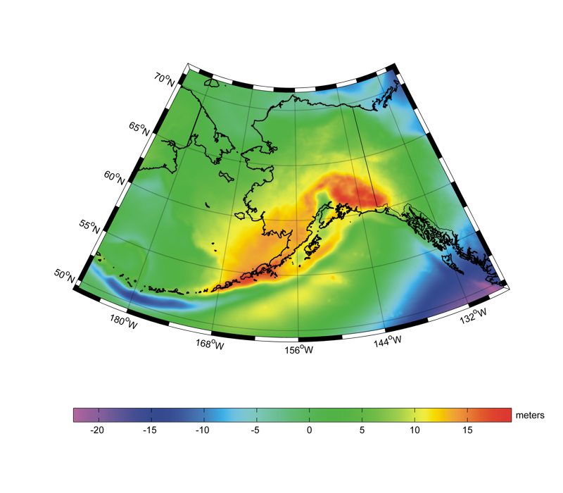
Description:
USGG2009 is a gravimetric geoid model for Alaska computed by the National Geodetic Survey (NGS). It is referred to the GRS80
normal ellipsoid in the ITRF00 frame. It has a 1'x1' spatial resolution in latitude and longitude. It is based on terrestrial and
ship-borne surface gravity data from the NGS database and DNSC08 altimetry-derived gravity over the oceans. The geoid determination
is performed in the framework of a remove-restore procedure, where long wavelengths come from the EGM2008 geopotential model.
In particular the USGG2009 model is based on the use of the one-dimensional spherical Fast Fourier Transform (FFT) with a modified
Stokes kernel that retained all signal below degree 120 from EGM2008. The digital elevation model used for the terrain correction has
a 3"x3" spatial resolution and it is mainly based on SRTM-DTED1. By comparing the USGG2009 model with the available 176 GPS/levelling
benchmarks (ITRF00/NAVD88) in Alaska, a systematic offset is present with an average of 1.270 m and a standard deviation of 24.3 cm. The
GEOID09 hybrid model for Alaska is computed by fitting these GPS/levelling data (NAD83/NAVD88) with the USGG2009 gravimetric model, also
taking into account the relationships between NAD83 and ITRF00 reference frames. The fitting is performed by multi-matrix least squares
collocation after removing a trend to the residuals. Therefore the GEOID09 model directly relates NAD83(CORS96) ellipsoid heights and NAVD88
orthometric heights. The differences between GEOID09 and GPS/levelling benchmarks (NAD83/NAVD88) have a zero average and a standard deviation
of 0.6 cm.
References:
Y.M. Wang, J. Saleh, X. Li, D.R. Roman (2012). The US Gravimetric Geoid of 2009 (USGG2009): model development and evaluation.
Journal of Geodesy, 86(3), pp. 165–180. DOI: 10.1007/s00190-011-0506-7
D.R. Roman, Y.M. Wang, J. Saleh, X. Li. (2010). Geodesy, geoids, and vertical datums: A perspective from the US National Geodetic Survey. Proceedings of the
FIG Congress 2010, Facing the Challenges – Building the Capacity Sydney, Australia.
D.R. Roman, Y.M. Wang, J. Saleh, X. Li. (2009). Final National Models for the United States: Development of GEOID09. Technical Report, NOAA/National Geodetic Survey.
D.R. Roman, Y.M. Wang, J. Saleh, X. Li. (2009). A Gravimetric Geoid Model for the United States: The Development and Evaluation of USGG2009. Technical Report, NOAA/National Geodetic Survey.
Web of Science ID:
DRCI:DATA2018029012462751
|