Description:
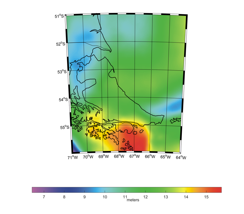
RIO2QG_2025 is a local, high-precision, high-resolution, pure-gravimetric quasigeoid model developed for the area surrounding RIO2, an International Height Reference Frame (IHRF) station located in the Province of Tierra del Fuego, Argentina, covering latitudes 56°S to 51°S and longitudes 71°W to 64°W, with a 0.03° grid resolution. The model’s purpose is to determine the IHRF vertical coordinate at this station. Its computation followed Molodensky’s formulation of the Geodetic Boundary Value Problem (GBVP) and employed the remove–compute–restore (RCR) strategy. Long-wavelength components were modeled using the XGM2019e Global Geopotential Model (GGM) up to degree and order 700. Topographic contributions were modeled via Residual Terrain Modeling (RTM) using the SRTM v4.1 Digital Elevation Model (DEM). Residual height anomalies were calculated with either the 1D-FFT technique incorporating the Wong-Gore modification to Stokes’ kernel or the Least-Squares Collocation (LSC) technique. All computational steps were performed with the GRAVSOFT software package. Validation against 41 GNSS/leveling points yielded an estimated precision of 0.061 m for the FFT solution and 0.066 m for the LSC solution, both after applying a four-parameter fit.
Model Citations:
A.R. Gómez, C. Tocho, E.D. Antokoletz, S.R. Cimbaro (2025). The gravimetric quasi-geoid of Tierra del Fuego Province based on FFT with modified Stokes kernel: AGGOQG_FFT_2025. V. 1.0. GFZ Data Services. DOI: 10.5880/isg.2025.005
A.R. Gómez, C. Tocho, E.D. Antokoletz, S.R. Cimbaro (2025). The gravimetric quasi-geoid of Tierra del Fuego Province based on Least Squares Collocation: AGGOQG_LSC_2025. V. 1.0. GFZ Data Services. DOI: 10.5880/isg.2025.006
Reference:
A.R. Gómez, C. Tocho, E.D. Antokoletz, S.R. Cimbaro (2025). Local quasigeoid modeling at Argentinean stations of the International Height Reference Frame (IHRF). Journal of Geodesy, 99, 94. DOI: 10.1007/s00190-025-02018-5
Digital object identifiers:
DOI: 10.5880/isg.2025.005 (FFT quasi-geoid in ISG format)
DOI: 10.5880/isg.2025.006 (LSC quasi-geoid in ISG format)
|