Kingdom of Saudi Arabia (KSA-GEOID21)
|
Authors: R.S. Grebenitcharsky, et al.
|
Created: 2021
|
Resp: Sultan Al-Shahrani
|
Description:
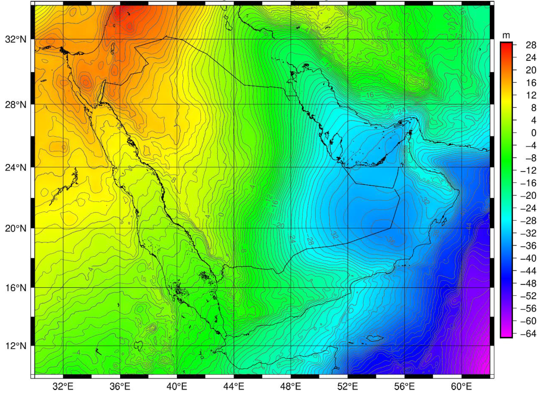
The General Authority for Survey and Geospatial Information (GEOSA) has developed an accurate, geocentric geoid model, KSA-GEOID21, combining all available relevant data in the Kingdom of Saudi Arabia. This task comprised two main phases. The first one focuses on the creation of an accurate and consistent gravity database by selecting and merging all the available gravity data sets, i.e. land, marine and airborne gravity measurements. Initially, a pre-processing of the land and marine gravity data was carried out, in order to achieve the quality check and homogenization of the data regarding the geodetic reference system, the vertical reference datum and the tide conventions. Moreover, a Least Square Collocation-based blunder detection and removal process, applied to all gravity data, resulted in further consistency of the compiled gravity database, which was considerably improved by adding the recently acquired airborne gravity data, which covers almost 68% of the Kingdom's territory. In addition, satellite altimetry data were used as fill-in for areas with no shipborne gravity, as well as EGM2008-based data for the neighbouring countries where no gravity data were available.
The second main phase refers to the determination of (a) a gravimetric-only geoid model for KSA using the aforementioned new gravity database and (b) a hybrid geoid model based on gravity and GNSS/Levelling data by fitting to selected GNSS/levelling heights distributed over the country. Both geoid models were computed following a remove-compute-restore scheme, where residual terrain model effects were used to account for the contribution of the topography/bathymetry and the selected GGM for the long to medium wavelengths of the gravity spectrum. For the gravimetric geoid determination, both deterministic and stochastic methods were employed, the former referred to the FFT-based solution of Stokes' integral and the latter to LSC. Specifically, the geoid model for the entire country was determined by the 1D-FFT technique due to its computer-time efficiency, although in specific sub-areas, LSC was also applied for comparison purposes. In the last stage of this second phase, the validation of the gravimetric geoid models was performed in terms of absolute and relative accuracy estimates with respect to GNSS/Levelling data in land and satellite altimetry data at sea regions.
The summary of the KSA-GEOID21 is presented below:
- - Covered area from 10°N to 35°N in latitude (grid step of 0.02°) and from 30°E to 62°E in longitude (grid step of 0.025°);
- - EGM XGM2019e reference field (incorporating GOCE, GRACE and LAGEOS satellite data);
- - New DTU18 satellite altimetry data offshore;
- - More than 760000 land gravity data and more than 158000 marine gravity data from both new (GEOSA) & the older (ARAMCO + others) data sources;
- - New dataset of airborne gravity data covering almost 68% of the KSA territory;
- - The gravimetric geoid is fitted to the new KSAVRF14 through a set of 3522 GEOSA GPS/levelling points along the National Vertical Network;
- - The fitted geoid KSA-GEOID21 has the following expected precision with respect to the Corrector Surface (CS):
- - Standard Deviation: 1.5 cm along the levelling lines; Confidence Interval (99.7%): ±4.5 cm;
- - Standard Deviation: 2.5 cm between the levelling lines; Confidence Interval (99.7%): ±7.5 cm.
References:
R.S. Grebenitcharsky, G.S. Vergos, S. Al-Shahrani, A. Al-Qahtani, G. Iuri, A. Othman, S. Aljebreen (2023). Hybrid geoid modeling for the Kingdom of Saudi Arabia. In: J.T. Freymueller, L. Sànchez (eds), Gravity, Positioning and Reference Frames, REFAG 2022. IAG Symposia, 156, pp. 63-69. DOI: 10.1007/1345_2023_215
GEOSA (2024). National Geoid Model KSA-GEOID2021. Technical summary for Saudi Arabia National Spatial Reference System (SANSRS), Riyadh, Kingdom of Saudi Arabia, pp. 34-64
|
|

